
Outdoor surveying
Simplify everything.
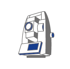
Leica Builder and Hilti Pos are compatible devices with our modelers.
Pair your device in real-time or import your survey through a USB stick to base your design, your measurements and your production on reliable and extremely accurate measurements.
The dynamic mode (direct connection to the pc) brings a real time and simplified visualization allowing you to quickly handle data.
Building utilities :
Different measurement points took by a tacheometer (existing building, slab survey, etc…) are transmitted directly to cadwork 3D.
The result then appears in real time as nodes, lines and surfaces in cadwork 3D and cadwork Design.

The drawing can then be revised directly in cadwork 3D and returned to the tacheometer. The device will point with extreme precision at the changes made directly on site.
Civil Engineering :
A three-dimensional terrain survey made by a surveyor using a tacheometer can simply and quickly be modeled in cadwork 3D via the Terrain module.
It is then possible to design and draw a structure in cadwork 3D taking into account the real topography in order to exploit various information such as:
- Fill volume / Excavation
- Topographic data for stake-out
- Production data (construction on sloped ground)
- Landscape integration
INDOOR SURVEYING
Accurate measurements without reflector – Direct link with cadwork 3D – Recommended for interior design
A 3D DISTO is a unique instrument that captures and reflects accurate three-dimensional measurements. The speed and accuracy of a 3D DISTO offers an unmatched efficiency for applications such as:
Creating CAD/CAM models :
Fabrication on a CNC machine will exactly match the quality of your file. The 3D DISTO is a bridge between reality and your CAD/CAM model. When you make custom cuts and you know that the original measurements are accurate, you can cut the most expensive materials in total confidence.
3D visualization and navigation: The Leica DISTO 3D software now updated for smart devices using Windows® will display the results in 3 dimensions.
With 3D navigation, it’s even easier to verify the measured points.
Measurements in accordance with the execution:
The best way to eliminate future surprises on a job site is to know where you started. The 3D DISTO captures exact 3D coordinates with the precision needed for planning. If you are working with expensive materials that are difficult to cut or transport or even some that are processed off-site, “as-built” measurements are essential.
Building Information Modeling (BIM):
Transfer DXF data directly into your Windows tablet and use 3D DISTO to stake anchor points, transfer heights or verify critical parts of your construction.
Whatever you do with your 3D DISTO, accuracy is essential. The function determines the shape and that is why the 3D DISTO looks like a fusion between a surveyor robot and a portable DISTO.
The horizontal and vertical motorized rotation axes of the 3D DISTO are like an automated turret; Manually move the laser point close to the right starting point then aim with the video by tapping the target on the image of the control unit or on a Windows tablet. Then, watch the 3D DISTO rotate and tilt until the laser dot is right in the center of the cross.
The laser is pretty stunning with its accuracy of 1 mm to 10 m (± 1/16″ to 33′). In fact, to take measurements of this accuracy, the device uses a technique borrowed from topographic equipment (it measures an horizontal angle, a vertical angle and a slope distance and then converts them into XYZ coordinates).
MODULES
This solution uses the following modules :
TEST OUR SOLUTIONS
You have the possibility to test the cadwork solutions for 2 months before making your decision! Following a 2-day training course, you receive a complete and free trial version valid for 2 months, including telephone assistance and all our services.
ALL SUCCESSES OF OUR CUSTOMERS
HANROT FORNAGE
Modeling of a ramp for a sports event, using the photogrammetry technique for on-site measurement.
Read more